Property Record
1165 N Main St, Lillington, NC 27546
NEARBY LISTINGS FOR SALE OR LEASE
-
-
View all Lillington listings for sale on LoopNet.com
Property Detail
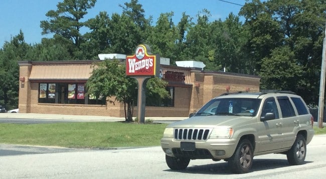
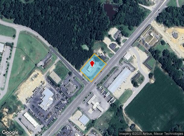
1165 N Main St
110650 0026
Allied Wenco International Inc
Restaurantdrivein
0.898AC ALLIED WENCO INTLMAP#2003-793
X
Harnett
3720064000J
North Carolina
2025
0.90 AC
2025
Other Market Areas
070801
Dunn, NC
3,383 SF
DEMOGRAPHICS near 1165 N Main St
1 Mile
3 Mile
5 Mile
2024 Total Population
512
7,626
17,093
2029 Population
560
8,365
18,679
Pop Growth 2024-2029
+ 9.38%
+ 9.69%
+ 9.28%
Average Age
43
43
40
2024 Total Households
176
2,778
6,052
HH Growth 2024-2029
+ 10.23%
+ 10.44%
+ 10.05%
Median Household Inc
$58,157
$58,059
$57,252
Avg Household Size
2.40
2.40
2.40
2024 Avg HH Vehicles
2.00
2.00
2.00
Median Home Value
$211,290
$210,271
$213,670
Median Year Built
1993
1992
1994
Nearby Places
Map Layers
Map Styles
 Street
 Aerial
- Restaurants
- Banks
- Shops
- Fitness
- Groceries
PUBLIC TRANSPORTATION
AIRPORT
Fayetteville Regional/Grannis Field
DRIVE
WALK
Distance
Fayetteville Regional/Grannis Field
52 min
34.2 mi
Freight Ports
Port of Wilmington
DRIVE
WALK
Distance
Port of Wilmington
146 min
119.8 mi
SALE & LEASE HISTORY
LISTING DATE
SALE/LEASE

Sep 24, 2016
For Sale
Nearby Properties
Address
Land Use
TOTAL SIZE
Lot Size
Zoning
Address
Land Use
TOTAL SIZE
Lot Size
Zoning
9.12 AC
R20
Address
Land Use
TOTAL SIZE
Lot Size
Zoning
1,715 SF
5.36 AC
Address
Land Use
TOTAL SIZE
Lot Size
Zoning
42,958 SF
14.51 AC
RA20M
Address
Land Use
TOTAL SIZE
Lot Size
Zoning
294,958 SF
29.27 AC
HI
Address
Land Use
TOTAL SIZE
Lot Size
Zoning
89,919 SF
15.77 AC
OI
Address
Land Use
TOTAL SIZE
Lot Size
Zoning
50,750 SF
12.41 AC
C3
Address
Land Use
TOTAL SIZE
Lot Size
Zoning
46,709 SF
6.49 AC
OI
Address
Land Use
TOTAL SIZE
Lot Size
Zoning
33,166 SF
2.75 AC
C3
Address
Land Use
TOTAL SIZE
Lot Size
Zoning
31,002 SF
8.57 AC
Address
Land Use
TOTAL SIZE
Lot Size
Zoning
59,070 SF
13.49 AC
Address
Land Use
TOTAL SIZE
Lot Size
Zoning
20,145 SF
5.46 AC
C3
Address
Land Use
TOTAL SIZE
Lot Size
Zoning
49.29 AC
Address
Land Use
TOTAL SIZE
Lot Size
Zoning
4,353 SF
1.27 AC
C3
Address
Land Use
TOTAL SIZE
Lot Size
Zoning
55,246 SF
11.48 AC
Address
Land Use
TOTAL SIZE
Lot Size
Zoning
53.66 AC
OI
Address
Land Use
TOTAL SIZE
Lot Size
Zoning
10,125 SF
1.04 AC
C1
Address
Land Use
TOTAL SIZE
Lot Size
Zoning
57,480 SF
11.54 AC
Address
Land Use
TOTAL SIZE
Lot Size
Zoning
50,000 SF
3.59 AC
Address
Land Use
TOTAL SIZE
Lot Size
Zoning
85,584 SF
6.78 AC
Address
Land Use
TOTAL SIZE
Lot Size
Zoning
14.10 AC
IND
Address
Land Use
TOTAL SIZE
Lot Size
Zoning
4,764 SF
4.15 AC
C3
Address
Land Use
TOTAL SIZE
Lot Size
Zoning
3,512 SF
0.93 AC
C3
Address
Land Use
TOTAL SIZE
Lot Size
Zoning
14,970 SF
1.49 AC
R10
Address
Land Use
TOTAL SIZE
Lot Size
Zoning
154.23 AC
RS20
Address
Land Use
TOTAL SIZE
Lot Size
Zoning
26,718 SF
6.17 AC
OI
Address
Land Use
TOTAL SIZE
Lot Size
Zoning
2,172 SF
132.76 AC
RS20
Address
Land Use
TOTAL SIZE
Lot Size
Zoning
3,650 SF
1.10 AC
C3
Address
Land Use
TOTAL SIZE
Lot Size
Zoning
11,736 SF
1.27 AC
C3
Address
Land Use
TOTAL SIZE
Lot Size
Zoning
24,749 SF
1.13 AC
C3
Address
Land Use
TOTAL SIZE
Lot Size
Zoning
21.52 AC
The World's #1 Commercial Real Estate Marketplace
Connect with us
© 2025 CoStar Group
The information above has been obtained from sources believed reliable. While we do not doubt its accuracy we have not verified it and make no guarantee, warranty or representation about it. It is your responsibility to independently confirm its accuracy and completeness. Any projections, opinions, assumptions, or estimates used are for example only and do not represent the current or future performance of the property. The value of this transaction to you depends on tax and other factors which should be evaluated by your tax, financial, and legal advisors. You and your advisors should conduct a careful, independent investigation of the property to determine to your satisfaction the suitability of the property for your needs.